
Civic Exchange (思匯政策研究所,“CE” hereafter, a think tank) held a workshop on Covering Open Space 101 Workshop in HKBU on 7 Feb 2018, as a part of the collaboration with HKBU JOUR to conduct a series of investigative reports on open space in Hong Kong. CE’s researcher, Carine Lai and an experienced journalist, Christopher DeWolf, were invited to share their experience and techniques in doing open space research in Hong Kong. After the learning sessions, students tried to use the maps to practice the knowledge learned from the workshop. Here is the recap of the event.
The process of making an open space story
- Searching anecdotes for coloring the story
- Designing the initiative
- Find expert commentary
- Get government response
How to receive the response from government?
- Telephone directory
- Find the relevant departments
- Contact the information services department
- Send questions with specific deadline
Definition of open space in Hong Kong
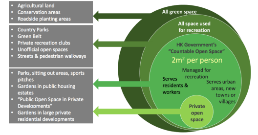
Figure 1. Definition of open space in Hong Kong. Source: Carine Lai, Civic Exchange.
Who provides open space in Hong Kong?
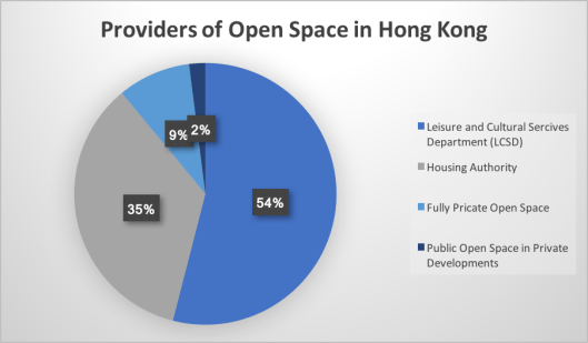
Figure 2. Open space providers in Hong Kong. The Figure is made by Emily Xu, derived from the talk.
* Most of the news is conducted on “Public Open Space in Private Developments” which accounts for 2 % of open space in Hong Kong.
Types of data can be used:
- Comprehensive data (Planning Department): It is not published regularly and only 2008 and 2012 (requested from Planning Department) data was published. And it provides PDF documents only.
- Zoned open space (Town Planning Board): It provides more details than 18 districts, including 71 urban OZPs, and 74 rural OZPs. But it does not include all categories, and not all the planning intention is true. Current and historical plans are both available but historical plans are only in the paper version.
Sources: Outline Zoning Plan Notes current versions online at Statuary Planning Portal and historical versions from Planning Department’s Planning Enquiry Counters.
- LCSD-administered open space: The reports are published annually. However, it does not have the district-level breakdown, and it includes roadside planting areas which LCSD maintain.
Missing data:
- Master layout plans for private developments. It should be viewed by the public at the Land Registry.
- Development briefs for public housing estates, which is not available to public generally
Additional resources:
- Hong Kong Public Space Initiative. It is an open-space map, with locations, which are managed publicly or privately.
- Lands Department. It provides accurate maps and aerial photos. Moreover, there are distance and area measuring tools. Downloadable directories of public facilities are available as well.
- Census and Statistics Department. It provides most up-to-date demographic data, distance, and area measuring tools and downloadable directories of public facilities. However, it is unavailable for small geographical areas.
Role of the media:
- Expand public’s understanding
- Demand transparency (code on access to information)
- Hole government and private sector accountable
Practices:
Author: Emily Xu
